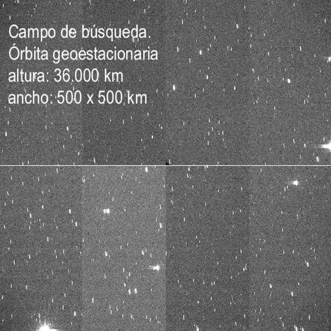
Figure 1. Typical image obtained in a night of observation (0.7 ° x0.7 °).
As can be seen in the picture above, a degree in the field of view equivalent to a distance of about 700 km in the geostationary ring. After campaigning for January and February of 2001 and after 30 nights of observation, were nothing more and nothing less than 27,000 images and about 4800 degrees were filled sky 2. However there is still much work to do, since only a small portion has tracked the geostationary ring.
How do you detect objects?
The objects are moved into geostationary orbit at the same speed as Earth. That is, to a ground observer appear in the same position in the sky. If we take a few seconds of exposure with the telescope stopped, the stars of our field of vision will leave a trace on the image, while the geostationary objects appear as points, then move with the earth.
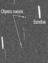
Figure 2. Details of geostationary objects in a typical image.
Once taken the exhibition, the telescope corrects its position to "follow" the same field, stops and turns to take further exposure. Thus, an object in geostationary orbit will appear in several pictures, then it will gradually moving in right ascension. In the case of satellites or objects very big these "points" can be seen with the naked eye in an image of hands. However, for most of the objects is a necessary process of detecting something more elaborate.
Processing of the images.
The Astronomical Institute of the University of Bern, Switzerland (AIUB), has developed an complex image processing software that enables the easy way to process the data obtained in a night of observation, using highly intuitive graphical interfaces.
The search procedure is mainly based on the use of a mask. The program makes all the images for a series (remember that in a field observation, there are two series), combines them and get a picture of median. Using this image average, the next step is to create a mask: an image of the field with the stars in the negative. So when you apply this mask to each of the images in the series, the stars are "hidden" and the only thing that will be the geostationary objects. And cosmic rays? Of course, also applies a filter detection of cosmic rays (based on the shape of the intensity profile) to locate and mark on the image. Since this procedure operates frame by frame, it is necessary to correlate the detected objects. The result is a list of objects detected in more than one picture, as well as another list of objects that appear on a single image.
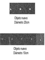
Figure 3. Examples of geostationary objects detected.
In Figure 3. two objects can be geostationary. The program creates a sort of "sub image" which appears only detected the object and, if that is found in more than one picture in the series, presented in a package.
When it detects an object, their celestial coordinates are calculated using as a reference stars scheduled to appear in the image and a program to coordinate transformation of the RCD to celestial coordinates.
The last step of processing the images is the determination in the first approximation of the orbital elements of a circular orbit of the object. It also presents calculation errors and an estimate of the size of the object. These orbital parameters are compared to TLEs already cataloged objects, so if it has detected an object known, his name appears identifying the catalog that we are using.
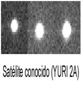
Figure 4. Geostationary object cataloged.
The remaining objets are considered to be new objects and will be marked with an identification number consisting of four figures over the image name in which it appears.
Some results.
After campaigning for January and February (making a total of 30 nights of actual observation), were obtained about 120 gigabytes of data, covering more than 26,000 images. It has covered an area of sky for more than 4,500 degrees 2, which equates to about 2,300 million km 2 in the geostationary ring.
The data obtained during the campaign in February are yet to be analyzed. In the campaign for January were a total of 316 detections of geostationary objects not listed, although this number includes multiple detections of the same object.
The set-telescope camera, coupled with the superb weather conditions of the Teide Observatory, make the system reach to detect objects of magnitude 21, ie below 10 cm in diameter, although the vast majority of objects not cataloged detected so far have diameters ranging between 10 and 60 cm. The population of objects seems to grow steadily as we move towards greater magnitudes (objects weakest).
And in the future ...
The space debris project consists in two parts. In the first part catalog is the largest possible number of objects in GEO; at a later stage, will focus on objects in GTO, performing, in addition to cataloging, tracking them to more accurately determine their orbital parameters (semi-major , Inclination, eccentricity, etc.).. It also intends to create, from the results in the first phase of GEO, a catalog, which allows the subsequent identification of detected objects, and the improvement of those first assigned orbits.
|
