Orbit: The path that follows an artificial satellite circling the Earth. For each type of orbit has a speed of the satellite. If the satellite change speed, change of orbit. The satellites in orbits that are closest traveling faster than those who are at higher altitudes.
Orbital inclination: angle formed between the orbit of the satellite and terrestrial equator.
Perigee: Minimum distance from the satellite to the center of the Earth.
Apogee: Maximum distance from the satellite to the center of the Earth.
Introduction
Isaac Newton stated in 1686 his theory of universal gravitation, which lays the theoretical basis for the use of artificial satellites. Later in 1903, the Russian Konstantin Tsiolkovski publishes first academic treaty on the use of rockets to place objects in orbit around the Earth. The engineer Slovenian Herman Potocnik in 1928 describes the use of orbiting spacecraft for military and peaceful comments and how they could use the space to conduct scientific experiments, as well as the possibility of geostationary satellites. In 1945 the British science fiction writer Arthur C. Clarke suggests the possibility of establishing a network of satellites, noting that three geostationary satellites located at 120 each, would provide full coverage of the planet.
On October 4, 1957, the former Soviet Union launched the first artificial satellite, Sputnik 1. Currently there are more than 8,000 objects orbiting human manufacture on Earth. These objects can weigh several tons since, as remnants of rockets, until just a few kilograms. About 7% of the space objects are operational, some 560 satellites, while the rest are so-called space debris.
Types of satellites:
Although theoretically the orbits of satellites can be circular, however, in practice, are elliptical with various eccentricities.
You can establish a ranking of the satellites in relation to its orbit:
Altitude:
Non-geostationary satellites. In turn are divided into two classes:
Low Earth Orbit (LEO), located 400km from up to 2,000 km. altitude.
Middle Earth orbit (MEO), located in an orbit between 2,000 km and geostationary.
Both the MEO as the LEO satellites, for its lower altitude, have a speed pass around the earth faster than the Earth's rotation (24h).
Geostationary satellites (GEO). They are in the orbit of the same name, on the Equator and at an altitude of nearly 36,000 km. Rotate at the same speed as Earth, so that an observer on the ground the satellite appears to be a fixed point in the sky.
By type of orbit:
Inclined orbit. One whose orbital inclination is not zero.
Polar orbit. Which has an orbital inclination of 90 degrees (passing over the poles of the planet).
Uses
According to the use, artificial satellites can be classified as:
- Communication (Hispasat)
- Navigation (GPS)
- Meteorological (Meteosat)
- The study of terrestrial and marine resources (LANDSAT)
- Military and espionage (DSP)
- Scientists (Hubble telescope).
Edward W. Ploman, telecommunications expert, distinguishes two broad categories:
Observation satellites. For the capture, processing and transmitting data to and from Earth.
Communication satellites. For the transmission, distribution and propagation of information from various locations on Earth to other different positions. Observing artificial satellites
To observe artificial satellites should lie in a dark place, away from urban centers with clear horizons.
The satellites are visible because they reflect sunlight. Appear in the sky like a star that is moving at a certain speed without producing flashes as the planes. The brightness of the satellites is expressed in magnitudes, similarly to that of the stars. The size of a satellite depends on your distance from the earth, its size and albedo, or the relation between the incident and the reflected light.
The satellites are visible to the naked eye kind of LEO, so it can be seen shortly after sunset or just before sunrise, as they are illuminated by sunlight, while that for us the sun is under the horizon . During his movement across the sky often the satellite enters the shadow projecting the Earth, so we no longer see them.
According to the directions of movement in the sky satellites are grouped into:
• Those who move from west to east (or equatorial orbit inclined).
• Those who move from south to north or vice versa (polar orbit).
Sometimes there are variations in brightness, with periods of a few seconds, which are due to the rotation of the satellite on its own.
One exception among them the Iridium satellite network. Used for telephony overall, with flat antennas have a very reflective material, so that when the observer is geared toward producing a flash (several seconds) that can reach the magnitude -8 (about 15 times brighter than the planet Venus ).
The satellites are the brightest Iridium, the International Space Station (ISS) and the space shuttle in his travels.
Today in History for the visibility of satellites
Orbitron (http://www.stoff.pl): Excellent free software (cardware) satellite tracking. Requires Internet connection to update the orbital data of satellites.
Heavens-Above (http://www.heavens-above.com): The best site to obtain ephemeris for observation satellites, including flashes of Iridium, steps from the ISS and other data. From the geographical position of the observer (entered numerically or by interactive maps), are dropped into a menu to select the satellite and get the data of observation.
Human Space Flight (http://spaceflight.nasa.gov/realdata/tracking/index.html): Follow-up to the ISS in real time, with updated data at the time (NASA).
Calculating the height of an artificial satellite
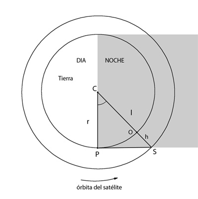
It is possible to calculate the approximate height of an artificial satellite by a simple visual observation. This should chalk up the time at which the satellite disappears in the shadow land and know (or calculate) the time of the sunset. In this way, to an observer O, the triangle is formed of the CSP is attached (C being the center of the Earth, S, satellite position at the entrance in the shadow land, P, position on the surface to start Sol).
R is known (radius of the Earth), and the angle C is derived from the time of observation and time of sunset (both in hours and fractions), knowing that the Earth's rotation is 24 hours : 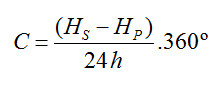
Then the length l is calculated by:
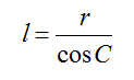
The height of the satellite is:
: 
|
